Sabarmati : Aravalli to Cambay
Sabarmati is a monsoon-fed river that originates in the Aravalli hills of Rajasthan near Udaipur and flows north-south through Ahmedabad, bisecting the city into its western and eastern halves. It covers a total distance of 371 km, out of which 48 km is traversed in Rajasthan and the remaining 323 km in Gujarat. Throughout its journey, it passes through a variety of landscapes and human settlements. This photo-essay tells the story of its changing landscape tracing its journey from its source to its end at the Gulf of Cambay.

Across Sabarmati river
River Sabarmati originates from Aravalli hills in the Udaipur district of Rajasthan. The Sabarmati is said to have derived its name from the term Svabhra (Svabhramati was its ancient name) which translates to crevices as it is said that the river travels mostly through crevices.

River Sabarmati near its origin around Aravalli hills in Udaipur, Rajasthan.
Photographer: Shalvi Suman | Year: 2018, April 1
Medium: 35 mm Digital SLR(Canon EOS 1200D) | Source: Photographer

Sabarmati meets it’s left bank tributary River Harnav in Mehsana District, Gujarat.
Photographer: Sumit Baruah | Year: 2017, March
Medium: 35 mm Digital SLR (NIKON D300) | Source: Photographer
Before Sabarmati enters Ahmedabad city, it is fed with waters from the Narmada canal which helps it retain its flow throughout the year.

Aerial view of Karai Dam and the point where water from Narmada is fed into Sabarmati.
Photographer: Shailesh Rawal | Year: 2007, October 30
Medium: 35 mm Digital SLR(Canon EOS 5D) | Source: Photographer
As the river enters Ahmedabad city, it loses its identity of a free-flowing river and is surrounded by urbanization on both the banks. But this was not the case always. Initially, when the city was established in 1411 by Ahmed Shah of Gujarat Sultanate, he chose the eastern bank of the Sabarmati to populate the city. Later the construction of the first bridge, Ellis Bridge in 1892, and the further construction of bridges in the first half of the 20th century, led to the growth of the city, on both the eastern and western banks of the river. Before these bridges were built, people used to cross the river on boats or by foot during the dry season.
Initially called ‘Lakkadiyo ka pul’ (wooden bridge), the old Ellis Bridge was heavily damaged due to the floods in September 1875. Thereafter, a new stronger Ellis Bridge was ordered by the Britishers, for which iron was imported from Birmingham. The new Ellis Bridge was constructed in 1892 by a Gujarati Engineer Himmatlal Dhirajram Bhachhech and it was named after Sir Barrow Helbert Ellis, who was the commissioner of the North zone.

Aerial view of Northern end of Ahmedabad city.
Photographer: Robert Stephens | Year: 2017, November
Medium: Digital Camera | Source: Photographer
Before the Sabarmati Riverfront Project came up, the Sabarmati river used to have a huge riverbed on both the banks. The riverbed served many purposes for the people of city especially for those living along the banks of the river.
For the project, a separate body, the ‘Sabarmati Riverfront Development Corporation’ was formed under the Ahmedabad Municipal Corporation in 1997. The river has been streamlined to a uniform width of 263 metres, with waterfront development along both banks, each covering around 11 km. It was inaugurated in 2012, and since then it has been partially opened for the public as the development of the riverfront is still on. Lands have been reclaimed on both the eastern and western banks of the river and the locals residing there have been relocated. The construction of the riverfront led to the abandonment of multiple activities which used to happen at the banks of the river such as washing, dyeing and drying of clothes and the weekly flea market held on Sundays. Both the banks have been beautified with artificial construction and development of parks and recreational centres. Apart from these recreational spots; commercial buildings and various other constructions have been planned around the riverfront. Although the project has been appreciated for its urban planning, it has also been criticized for its negligence towards the environment and natural water flows.

View of Sabarmati River.
Photographer: Rajagopalan Palamadai | Year: 1981, September-October
Medium: 35 mm color slide | Source: MIT Archives

View of Sabarmati near Rishi Dadhichi Bridge.
Photographer: possibly F. N. Pathan | Year: circa 1970
Medium: 35 mm Analog | Source: NID Archives

View of Sabarmati riverbed.
Photographer: Pushpa Chavda | Year: 1975
Medium: 120 mm Analog | Source: NID Archives

View of Sabarmati riverbed.
Photographer: Dashrath Patel | Year: circa 1960
Medium: 35 mm color slide | Source: NID Archives
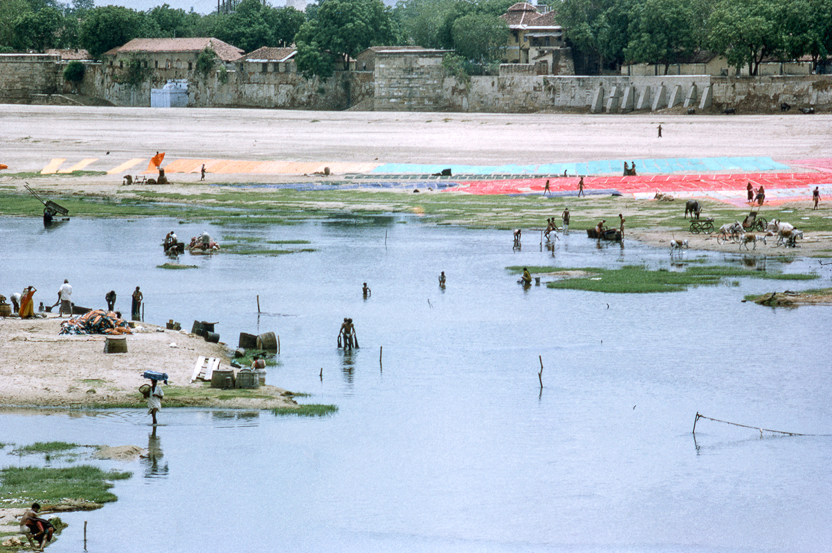
People washing and drying clothes along the Sabarmati riverbed.
Photographer: Dashrath Patel | Year: circa 1960
Medium: 35 mm color slide | Source: NID Archives
As soon as the river leaves Ahmedabad after the Vasna Barrage, it becomes a dumping ground for the city’s waste. It also gets severely polluted by the effluents discharged in it by various industries such as textile and chemical industries.

View of Vasna Barrage.
Photographer: Vishal Mehta | Year: 2016, October 23
Medium: 35 mm Digital SLR (NIKON D750) | Source: Photographer

Effluent being discharged into the Sabarmati.
Photographer: Amruta Pradhan, ATREE Bangalore | Year: 2014
Medium: 35 mm Digital SLR (Sony DSC-H200) | Source: SANDRP
Towards the end of its journey, the Sabarmati again enjoys the beautiful landscape around it as it passes mostly through barren lands with little urbanization. However, the river continues to be polluted through the wastes and effluents it receives from nearby towns and small cities along its way.

Confluence of Sabarmati River with one of its major left bank tributary Vatrak at Vautha where annual Vautha fair is held. | Photographer: Raj Maurya | Year: 2021, January 2
Medium: 35 mm Digital SLR(Canon EOS 70D) | Source: Photographer

Confluence of Sabarmati with its right bank tributary Bhogavo few miles before it falls into Gulf of Cambay.
Photographer: Raj Maurya | Year: 2021, January 2
Medium: 35 mm Digital SLR(Canon EOS 70D) | Source: Photographer

River Sabarmati ending its journey at Gulf of Cambay.
Photographer: Raj Maurya | Year: 2021, July 17
Medium: Medium format Digital SLR (PENTAX 645Z) | Source: Photographer
About the project :
The principal intent behind this project is to unravel the history of the Sabarmati River through photography-archives collected from various sources, to inform, and infuse introspection amongst the city’s inhabitant’s, policymakers and a broader audience on its importance in the state of Gujarat.
Raj Maurya a Photography Design student at the National Institute of Design (NID) India's Gandhinagar campus worked on this project as his graduation project with guidance from Rajesh Vora (Photographer and NID Alumnus) and Rishi Singhal (Discipline Lead, Photography Design, NID Gandhinagar). This project was supported by Living Waters Museum and Murthy Nayak Foundation. (Published in 2022)
About Raj Maurya
Raj Maurya is a photographer, archivist, researcher and communication designer whose practice revolves around art, culture and heritage. He has a keen interest in the History and Cultural Heritage of the Indian sub-continent. He has done his Masters in Photography Design from the National Institute of Design and currently working as Cultural Mapping Fellow for the project 'Mera Gaanv Meri Dharohar' under National Mission on Cultural Mapping by the Ministry of Culture. (Published in 2022)
Suggested Stories


